A report by geoscientists identifies an elevated geohazard risk to residents of the North Shuswap.
“We’re certainly concerned, we’re taking it very seriously and we encourage residents to do so too,” says Columbia Shuswap Regional District manager protect services/regional Fire Chief Sean Coubrough.
The 2023 Bush Creek East Fire burned mountainous slopes draining into Adams and Shuswap lakes and changed how the landscape absorbs precipitation. These watersheds now have the potential to generate post-wildfire geohazards that pose life loss risks to properties in the area.
CSRD hired BGC Engineering Inc. to identify locations with the highest life-safety risk from post-wildfire geohazards to assist the regional district with emergency management planning. The report explores possible scenarios where post-wildfire debris flows or floods could be triggered as well as detailed analysis of how certain areas could be impacted should a debris flow or debris flood take place. BGC has also considered possible options for mitigation of these risks.
BGC assessed 73 watersheds with a focus on debris-flow, debris-flood, and flood hazards that could pose risk to life in occupied buildings.
In their 90-page report, BGC included preliminary suggestions for emergency management actions that could correspond with each zone and provided a rainfall threshold model that provides rainfall intensity thresholds that could initiate post-wildfire debris flows.
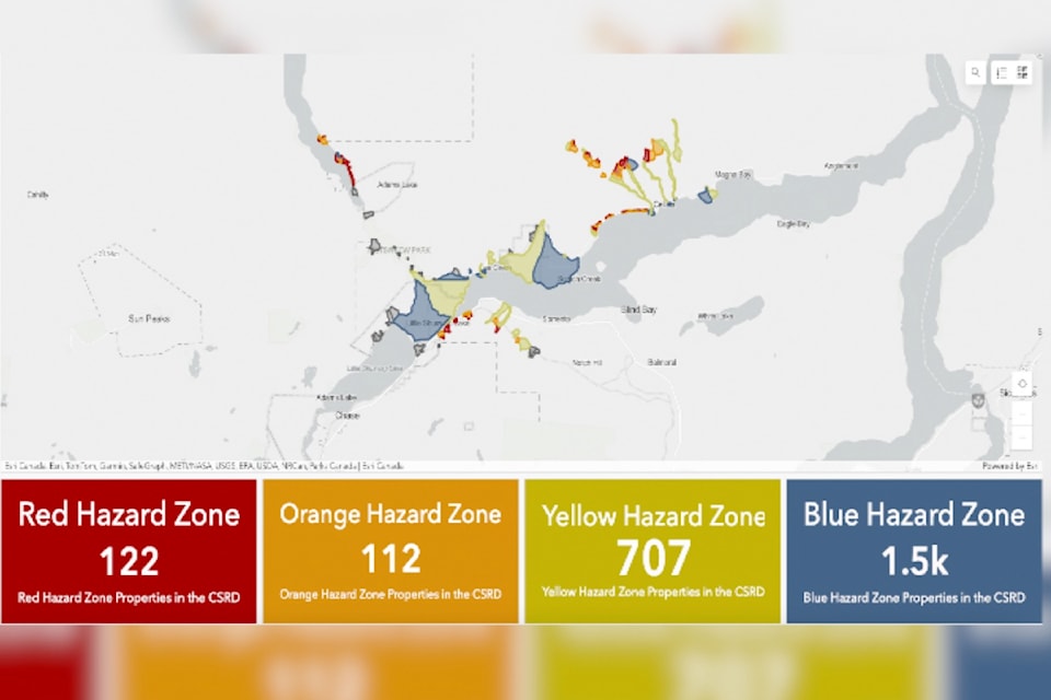
Each of the 73 watersheds susceptible to post-wildfire debris flows or floods were classified according to their potential risks and identified by colour – red being highest risk through to blue being the lowest. Twenty-five watersheds are in Red zones, 17 in Orange zones, 25 watersheds in yellow zones and 10 in Blue or lower risk zones.
BGC also provided the CSRD with recommendations for risk management across all affected areas as well as area-specific ones that consider the hazard zone mapping, existing building damage states of such items as unburned buildings or burned buildings, and type of infrastructure such as roads, bridges and culverts in the hazard zone.
Added to the damage caused by the Bush Creek East Wildfire, rain events now come into play. In the Shuswap Lake area, storms of sufficient intensity to trigger post-wildfire debris flows typically occur from April to November. In view of this, BGC recommends that CSRD considers implementation of an early warning system for the the four identified hazard zones. Coubrough says the regional district supports implementation of such a system and the Protective Services team is working with the Ministry of Emergency Management and Climate Readiness to obtain the necessary approvals.
Findings from the report were presented to community members at an in-person meeting at Quaaout Lodge on June 13, which was attended by 100 people and a Zoom meeting on June 17 for which 135 registered.
Technical information was provided by BGC Engineering geoscientists Carrie-Ann Lau and Chris Holm, Coubrough and Emergency Support Services Coordinator Cathy Semchuk.
Holm stressed the importance of choice in personal safety and suggested residents might vacate high-risk properties for two years.
“If you can hear our see a debris flow, it’s probably too late,” he said. “Small rain events can do more damage than imagined.”
Longtime ESS Coordinator Semchuk stressed the importance of having a grab-and-go bag available with important documents and medications and pet kennels, or sufficient food and water for those sheltering in place.
“Don’t just make a plan, share it,” she said of the importance of neighbours supporting each other.
Semchuk also recommended residents get a BC Services Card so ESS payments could be made quickly by Etransfer into individual bank accounts without the necessity of filling out forms during an event.
Following the presentation, panel members fielded many questions, from a geotechnical perspective to hydro seeding, unlicensed dams, potential effects of intense rain events, timber salvage and alternate escape routes for North Shuswap residents.
In terms of egress, Derek Sutherland, General Manager of Community and Protective Services, said he recently drove the road from Seymour Arm that was used by many during las summer’s wildfire. While passable, it is rough, he said.
“CSRD is lobbying the province to be proactive in upgrading forest service roads in the area.” He said. “We haven’t been successful yet, but conversations have just started.”
In response to requests for better signage, Sutherland indicated CSRD and the Ministry of Forests are working together to make and install road signs.
As he did during the presentation, Coubrough answered several requests for information on what the regional district is doing to advise and assist North Shuswap residents.
In response to watershed monitoring, Coubrough said Secwepemc Nation members are doing so and sharing information with the regional district. He noted there have been a few debris flows near Mt. Riley during intense rainfalls and urged residents to tell neighbours and take photos if they see anything of concern.
“The big message here is to stay informed and get the Alertable app,” he said, noting there is a wealth of information on the regional district’s Shuswap Emergency Program (SEP) site. “Information will also be going out through Shuswap Tourism and we’re looking at a number of other options.”
The two information meetings addressed public safety issues only. It will take additional time for CSRD Development Services staff to analyze the reports and determine how rebuilding efforts may or may not be affected.
In the meantime, the report, a video recording of the June 17 Zoom meeting, important documents and links, and a mapping dashboard that allows residents to see if their properties are in a risk area are available online at https://www.csrd.bc.ca/553/Bush-Creek-East-Landslide-Risk.
